Volcanoes in Iceland Near Reykjavik – 5 Closest Sites, Maps & Tours
Iceland’s position along the Mid-Atlantic Ridge means volcanic activity shapes daily life across the island, including in the capital. Reykjavik sits at the eastern edge of the Reykjanes Peninsula, a volcanic zone that has experienced frequent eruptions since 2021. Understanding which volcanoes lie closest to the city helps visitors and residents alike navigate this dynamic landscape safely.
Five major volcanic systems sit within 65 kilometers of Reykjavik, ranging from dormant sites with tourist access to actively monitored fissure rows. The Icelandic Meteorological Office tracks these areas continuously, providing public hazard maps and alert systems. Recent activity has concentrated on the Reykjanes Peninsula, where ten eruptions occurred between 2021 and 2024 alone.
What Are the Closest Volcanoes to Reykjavik?
50–55 km from Reykjavik
Active – Recent eruptions 2021–2024
Part of the Reykjanes volcanic system; first 2021 eruption began March 19
~65 km from Reykjavik
Active – Eruption in April 2025
Fissure row north of Grindavík between Sýlingarfell and Hagafell
~20–25 km from Reykjavik
Dormant – Non-erupting
World-unique magma chamber tours; visitors descend 120 meters underground
~25–30 km from Reykjavik
Active – Geothermal monitoring
Geothermal area with active seismic monitoring; no recent eruptions
- Four volcanic systems lie within 65 kilometers of Reykjavik, with three within a one-hour drive
- The Reykjanes Peninsula has produced ten eruptions since 2021, plus activity in 2025
- Þríhnúkagígur offers the world’s only accessible magma chamber for guided tours
- All sites remain accessible as day trips from the capital, subject to current conditions
- Reykjavik itself has experienced no direct impact from recent eruptions
- Hazard monitoring through vedur.is provides real-time updates for all volcanic zones
- The West Volcanic Zone, where Reykjavik sits, contains approximately 10–15 notable volcanic sites
| Fact | Detail |
|---|---|
| Total Iceland volcanic systems | ~30–33 active systems; ~130 total volcanoes |
| Nearest erupting site | Sundhnúkagígar, ~65 km southwest |
| Nearest accessible site | Þríhnúkagígur, ~20–25 km east |
| Most active domestically | Grímsvötn, Bárðarbunga, Hekla, Katla (overdue) |
| Current alert status | Color-coded system (0–3) via vedur.is |
| Recent eruptions (Reykjanes) | 10 events, 2021–2024; plus 2025 at Sundhnúkagígar |
| Threat to Reykjavik | Low – ash rarely reaches capital from Reykjanes eruptions |
| Closest active geothermal | Hengill, ~25–30 km east |
Map of Volcanoes Near Reykjavik
Multiple resources provide visual representations of Iceland’s volcanic landscape. The Icelandic Volcanoes catalogue maintains an interactive map of all 33 active systems, while Iceland-Dream.com highlights Reykjanes Peninsula activity specifically.
The Icelandic Meteorological Office publishes color-coded hazard maps for the Reykjanes Peninsula, with the most recent version issued March 31, 2026, covering zones near Fagradalsfjall. Updated assessments from April 15 address areas surrounding Sundhnúkagígar. Satellite imagery from Esri UK captures ground deformation and lava field changes from 2024 eruptions near Grindavík.
For current status, bookmark vedur.is, which refreshes volcanic system status daily at 09:00 UTC. The aviation color code map indicates current alert levels for each system. Always verify access conditions before visiting active zones.
Volcanic Zones Near Reykjavik
The West Volcanic Zone stretches across the Reykjanes Peninsula southwest of Reykjavik. This area contains the Fagradalsfjall and Sundhnúkagígar systems, both part of the same broader volcanic network. Brennisteinsfjöll also belongs to this zone, sitting roughly 30–40 kilometers southwest of the capital.
The Hengill system lies east of Reykjavik, closer to the city than the peninsula’s main eruption sites. While geothermal activity dominates this area, scientists monitor it continuously for seismic changes that might indicate magma movement.
Understanding Volcanic Alert Levels
Vedur.is uses a four-level alert system for volcanic activity. Level 0 indicates normal background activity, while Level 3 signals an eruption in progress or considered imminent. The aviation color code provides separate ratings for air traffic, ranging from green (no concern) to red (serious eruption ongoing).
Active Volcanoes Near Reykjavik and Current Eruptions
No live eruption was confirmed in current sources at time of publication. However, the Reykjanes Peninsula remains in a period of heightened activity. Iceland Tours documents that ten eruptions struck the peninsula between 2021 and 2024, with additional activity at Sundhnúkagígar in 2025.
Sundhnúkagígar experienced the most recent confirmed eruption in April 2025, prompting evacuations in Grindavík. The fissure row runs north of the town between Sýlingarfell and Hagafell, approximately 65 kilometers from Reykjavik. Fagradalsfjall, the first site to erupt in 2021, has produced multiple events through 2024, with the most recent documented eruption occurring in July 2024.
Recent Eruption Patterns
The frequency of eruptions on the Reykjanes Peninsula marks a significant shift from the preceding centuries of relative quiet. Scientists from Perlan’s research team note that this increased activity reflects complex interactions between magma chambers and tectonic stress along the Mid-Atlantic Ridge.
Grindavík has faced multiple evacuation orders as a result of this activity, with the Blue Lagoon spa temporarily closing during periods of heightened risk. Reykjavik itself has remained unaffected, with ash trajectories typically carrying material away from the capital.
The vedur.is hazard map page displays current volcanic alert levels for Reykjanes zones. The color-coded overlay indicates restricted areas and recommended access routes. Daily aviation codes provide additional indicators of current activity levels.
Monitoring Techniques
Scientists track volcanic activity through multiple networks. GPS stations across the Reykjanes Peninsula measure ground deformation caused by magma movement beneath the surface. Seismic monitors detect earthquake patterns associated with magma intrusions and chamber changes.
The Icelandic Meteorological Office integrates data from these networks to assess potential eruption signals. While the tools provide valuable insights, researchers emphasize that volcanic eruptions remain inherently difficult to predict with precision.
Best Volcanoes to Visit Near Reykjavik
Visitors to Iceland can explore several volcanic sites within day-trip distance of Reykjavik. Each offers distinct experiences, from dormant magma chambers to areas of ongoing geological change. Access conditions vary depending on current eruption activity and seasonal factors.
Þríhnúkagígur – The Magma Chamber Volcano
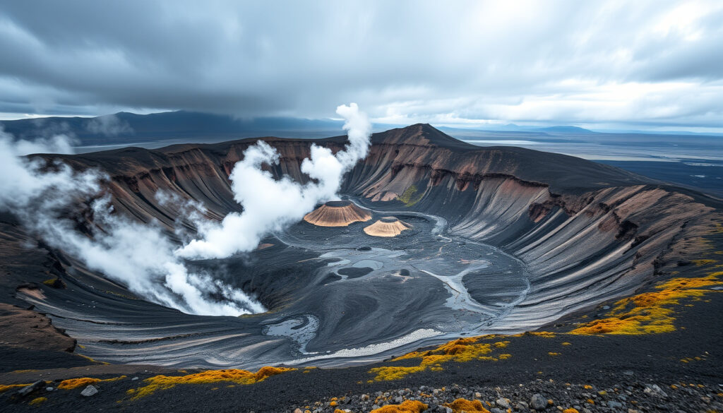
Þríhnúkagígur stands out as the world’s only site where visitors can descend into a preserved magma chamber. The volcano lies approximately 20–25 kilometers east of Reykjavik and has remained dormant for thousands of years. Guided tours lower participants 120 meters into the formation, providing access to volcanic structures typically hidden underground.
Tours operate seasonally and require booking in advance through official operators. Participants should be aware that the descent involves narrow passages, uneven ground, and temperature variations. A moderate level of physical fitness is recommended.
Fagradalsfjall – Recent Eruption Site
Fagradalsfjall offers the opportunity to witness the aftermath of recent volcanic activity. The site lies roughly 50–55 kilometers from Reykjavik and became accessible for hiking after the 2021 eruption. Visitors can traverse cooled lava fields and observe crater formations from multiple documented eruptions.
Trail conditions and access routes change following each eruption. Checking current restrictions before visiting remains essential, as authorities may close areas without notice.
Hengill – Geothermal Exploration
Hengill provides a different volcanic experience focused on geothermal activity rather than eruption sites. Hot springs and steaming vents characterize the area, which sits approximately 25–30 kilometers east of Reykjavik. Several hiking trails traverse the landscape, offering views of the surrounding volcanic terrain.
Unlike the active eruption sites, Hengill sees consistent access for outdoor recreation. The area remains monitored for seismic activity, but no eruption has occurred in recent history.
When visiting any volcanic site, always remain within designated areas marked by authorities. Eruptions can occur with limited warning, and conditions near active fissures pose significant hazards. Follow guidance from vedur.is and local emergency services. Road closures affecting routes to Reykjanes Peninsula sites, including access to the Blue Lagoon, may be implemented during periods of heightened activity.
Timeline of Recent Volcanic Activity Near Reykjavik
Understanding the sequence of eruptions helps contextualize current conditions on the Reykjanes Peninsula. The following timeline summarizes key volcanic events since 2021:
- March 19, 2021 – Fagradalsfjall erupts for the first time in approximately 800 years, marking the beginning of the current active period on the Reykjanes Peninsula.
- August 2022 – Fagradalsfjall produces a new eruption, with lava flows visible from monitoring stations.
- July 2023 – The Litli-Hrutur area experiences an eruption, part of the broader Fagradalsfjall system.
- December 2023 – Sundhnúkagígar erupts, initiating a series of events north of Grindavík.
- November 2024 – A 3-kilometer fissure opens at Sundhnúkagígar, representing one of the largest surface ruptures in the current period.
- April 2025 – Sundhnúkagígar erupts again, prompting evacuations in Grindavík. This event represents the most recent confirmed eruption near Reykjavik.
What We Know and What Remains Uncertain
Confirmed Information
The Reykjanes Peninsula has experienced repeated eruptions since 2021, with ten events documented through 2024 plus 2025 activity at Sundhnúkagígar. Reykjavik has not faced direct impacts from any of these eruptions. Multiple monitoring systems operated by the Icelandic Meteorological Office track activity across all nearby volcanic systems continuously. Þríhnúkagígur remains dormant, with tours running seasonally as a unique geological attraction. The hazard map system provides public-facing alert information updated regularly.
Unconfirmed Information
Scientists cannot predict precisely when the next eruption will occur or which volcanic system will be affected. The relationship between individual eruptions within the broader Reykjanes system requires ongoing research. Whether the current period of heightened activity will continue for years or decades remains unknown. Seismic and deformation data indicate magma movement occurring underground, though the significance and trajectory of these movements cannot be determined with current monitoring capabilities.
Why Iceland Has So Many Volcanoes Near Reykjavik
Iceland occupies a unique geological position where the North American and Eurasian tectonic plates meet along the Mid-Atlantic Ridge. This boundary runs directly through the island, with Reykjavik situated on the Eurasian plate side near the plate boundary. The result is a landscape where volcanic activity concentrates wherever the ridge interacts with a mantle hotspot beneath the crust.
The Reykjanes Peninsula lies along this boundary, making it one of the most volcanically active regions in the country. Magma from the hotspot rises through fractures created by plate separation, producing the eruptions that have become more frequent since 2021. Scientists monitor this process through networks of seismic stations and GPS instruments that detect the subtle ground movements associated with magma accumulation.
The proximity of active volcanic systems to Reykjavik reflects this underlying geology rather than any increase in overall activity. Iceland has always contained numerous volcanoes; improved monitoring simply reveals more detail about their behavior than was previously available.
Sources and Official Information
Multiple organizations track and publish information about volcanic activity in Iceland:
The Icelandic Meteorological Office serves as the primary scientific authority, operating monitoring networks and issuing public hazard assessments. Their website provides current volcanic alert levels, earthquake data, and hazard maps covering all active systems.
Perlan, a museum and observation point in Reykjavik, publishes informational articles about Icelandic volcanoes with contributions from geological researchers. The Guide to Iceland travel platform provides practical visitor information and current eruption updates. The Icelandic Volcanoes catalogue offers a comprehensive reference of all 33 active systems.
Several options exist for exploring volcanoes near Reykjavik, ranging from accessible geothermal areas to sites of recent eruption activity.
Perlan Museum, Iceland
Summary
The volcanoes nearest Reykjavik sit on the Reykjanes Peninsula, approximately 30–65 kilometers southwest of the city. Fagradalsfjall and Sundhnúkagígar have produced multiple eruptions since 2021, with Sundhnúkagígar erupting as recently as April 2025. For visitors seeking geological experiences without eruption risk, Þríhnúkagígur offers guided descents into a dormant magma chamber approximately 20–25 kilometers east of the capital. Hengill provides accessible geothermal landscapes for hiking and observation. Current monitoring through vedur.is allows anyone to check alert levels before visiting active zones. Those planning trips to Iceland should review the Met Éireann Snow Forecast for broader travel conditions and check Dublin Airport Holiday Warning for any flight-related advisories affecting departures to Iceland.
Frequently Asked Questions
How close is the nearest volcano to Reykjavik?
Þríhnúkagígur sits approximately 20–25 kilometers east of Reykjavik, making it the closest volcanic site. It is dormant and offers guided tours into its magma chamber.
Which volcano near Reykjavik is currently active?
Sundhnúkagígar, approximately 65 kilometers southwest of Reykjavik, erupted most recently in April 2025. The Reykjanes Peninsula overall remains in an active period with ongoing monitoring.
Can you visit Fagradalsfjall from Reykjavik?
Yes, Fagradalsfjall lies roughly 50–55 kilometers from Reykjavik and is accessible as a day trip. Trail conditions depend on recent eruption activity and should be verified before visiting.
How many volcanoes are there near Reykjavik?
Approximately 10–15 notable volcanic sites exist within day-trip distance of Reykjavik, with five major systems specifically identified within 65 kilometers.
Where can I find current eruption information?
The Icelandic Meteorological Office at vedur.is provides real-time volcanic status updates, hazard maps, and daily aviation color codes for all active systems.
Is Reykjavik at risk from volcanic eruptions?
Current monitoring indicates a low threat level for Reykjavik. Ash from Reykjanes eruptions typically disperses away from the capital, and no eruptions have directly impacted the city.
What is the most recent eruption near Reykjavik?
The most recent confirmed eruption occurred at Sundhnúkagígar in April 2025, prompting evacuations in Grindavík. Fagradalsfjall’s most recent eruption occurred in July 2024.
Can you go inside a volcano near Reykjavik?
Yes, Þríhnúkagígur offers guided tours that descend 120 meters into its dormant magma chamber. Tours operate seasonally and require advance booking.
More related posts
 How to Get Rid of a Headache Fast: NHS Tips
 Qatar Airway Dublin Terminal: Complete Terminal 1 Guide
 TV Guide Tonight Ireland: RTÉ, Virgin Media Listings
 Sweaty Betty Swiftie Running Cap: Worth the Price
 Minimum Wage for 16 Year Old Ireland 2026: Rates, Hours & Tax
 Coláiste Dún an Rí: Principal, Roll Number, Location
 Audi RS3 for Sale Ireland: Price & Specs Guide
 Cast of The Residence TV Series: Actors and Characters Guide